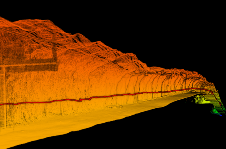
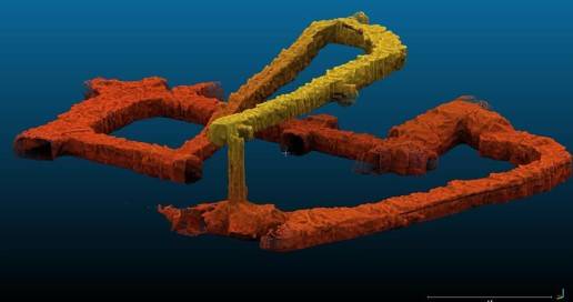
The mining industry is continuously evolving, driven by the need for greater efficiency, safety, and productivity. One of the most significant advancements in recent years is the development of 3D underground mine mapping. This technology provides a detailed, three-dimensional representation of underground mine structures, offering unprecedented insights into mine operations. In Africa, where mining is a major economic activity, the adoption of 3D underground mine mapping can lead to substantial benefits.
What is 3D Underground Mine Mapping?
3D underground mine mapping is the process of creating a three-dimensional representation of an underground mine. This involves the use of advanced surveying and imaging technologies to capture detailed data about the mine’s layout, including tunnels, shafts, and ore bodies. The resulting 3D model provides a comprehensive view of the mine’s structure, enabling better planning, monitoring, and management.

Components of 3D Underground Mine Mapping
- Surveying Technologies
- Imaging Technologies
- Data Processing Software
- Visualization Tools
How 3D Underground Mine Mapping Works
3D underground mine mapping combines various technologies to create a detailed model. Laser scanning and photogrammetry are commonly used to capture the physical features of the mine. The data collected is then processed using specialized software to generate a 3D model. This model can be viewed and analyzed using advanced visualization tools, allowing for detailed inspection and planning.
The Importance of 3D Underground Mine Mapping in Mining
Enhancing Safety
One of the primary benefits of 3D mine mapping is the enhancement of safety. By providing a detailed view of the mine’s structure, potential hazards can be identified and mitigated. This reduces the risk of accidents and ensures a safer working environment for miners.
Improving Efficiency
3D mapping allows for more efficient mine planning and operation. By understanding the exact layout of the mine, resources can be allocated more effectively, and operations can be optimized to reduce waste and increase productivity.
Facilitating Better Decision Making
Detailed, accurate data from 3D mapping supports better decision-making. Mine managers can use this information to make informed choices about where to focus mining efforts, how to manage resources, and how to address potential issues.
Current State of Mining in Africa
Economic Impact
Mining is a critical sector in many African countries, contributing significantly to national GDPs and employment. Major mineral resources such as gold, diamonds, and platinum are abundant, making mining a key driver of economic growth.
Challenges Faced
Despite its importance, the mining sector in Africa faces numerous challenges, including safety concerns, inefficient operations, and environmental impacts. Traditional mining methods are often inadequate to address these issues effectively.
How African Mines Can Benefit from 3D Underground Mine Mapping
Enhancing Mine Safety
3D mapping technology can significantly improve mine safety by providing detailed information about the mine’s structure. This allows for the identification of unstable areas and the implementation of measures to prevent collapses and accidents.
Increasing Operational Efficiency
By providing a precise map of the mine, 3D mapping enables better planning and resource allocation. This leads to more efficient operations, reduced waste, and higher productivity.

Reducing Environmental Impact
Accurate 3D maps help in minimizing the environmental impact of mining activities. By precisely targeting mining efforts, the disturbance to surrounding areas is reduced, and more sustainable practices can be implemented.
Supporting Economic Development
The adoption of advanced technologies like 3D mine mapping can boost the mining sector’s contribution to economic development. Increased efficiency and productivity lead to higher profits, more job opportunities, and greater investment in local communities.
Case Studies of 3D Underground Mine Mapping in African Mines
Case Study 1: AngloGold Ashanti’s Mponeng Gold Mine, South Africa
AngloGold Ashanti, one of the world’s leading gold mining companies, implemented 3D underground mine mapping at its Mponeng Gold Mine in South Africa. The mine, known for being one of the deepest in the world, required precise mapping to ensure the safety and efficiency of operations. By utilizing 3D mapping technology, the company was able to:
- Identify geological structures that posed risks to miners.
- Plan more efficient mining routes to access high-grade ore bodies.
- Enhance monitoring of ground stability and implement preventive measures.
As a result, AngloGold Ashanti saw a significant reduction in mining-related accidents and improved overall productivity.
Case Study 2: Petra Diamonds’ Cullinan Diamond Mine, South Africa
Petra Diamonds, a major player in the diamond mining industry, utilized 3D underground mine mapping at its Cullinan Diamond Mine. This technology helped the company to:
- Accurately model the complex underground structure of the mine.
- Optimize the extraction process to minimize waste and maximize yield.
- Monitor the condition of mine tunnels and shafts to ensure the safety of workers.
The implementation of 3D mapping technology led to increased efficiency in diamond recovery and reduced operational costs, contributing to higher profitability for Petra Diamonds.
Case Study 3: Glencore’s Mopani Copper Mines, Zambia
Glencore, a global mining and commodities trading company, introduced 3D underground mine mapping at its Mopani Copper Mines in Zambia. The technology enabled the company to:
- Develop a detailed understanding of the ore bodies and their spatial distribution.
- Plan more effective mining strategies to access copper ore efficiently.
- Improve ventilation systems and enhance the safety of underground operations.
The adoption of 3D mapping resulted in improved copper production rates and enhanced safety conditions for miners, demonstrating the technology’s potential to transform mining operations.
Implementing 3D Underground Mine Mapping in African Mines
Steps for Implementation
- Assessment of Current Practices
- Evaluate existing mining practices and identify areas that can benefit from 3D mapping.
- Selection of Appropriate Technologies
- Choose the right combination of surveying and imaging technologies suitable for the mine’s specific conditions.
- Training and Capacity Building
- Provide comprehensive training for mine personnel to ensure effective use of 3D mapping technology.
- Integration with Existing Systems
- Integrate 3D mapping data with current mine management and planning systems.
- Continuous Monitoring and Improvement
- Regularly update the 3D models and use the insights to continuously improve mine operations.
Overcoming Potential Barriers
Implementing 3D mine mapping can face challenges such as high initial costs, lack of technical expertise, and resistance to change. However, these can be addressed through strategic planning, investment in training, and demonstration of the technology’s long-term benefits.
Future Trends in 3D Underground Mine Mapping
Integration with AI and Machine Learning
The future of 3D underground mine mapping lies in the integration with artificial intelligence (AI) and machine learning. These technologies can enhance data analysis, predict potential issues, and automate various aspects of mine management.
Increasing Use of Drones
Drones are becoming increasingly popular in mining for their ability to capture detailed data quickly and safely. Combining drone technology with 3D mapping can provide even more accurate and comprehensive models of underground mines.
Advances in Visualization Technologies
As visualization technologies advance, the ability to create more detailed and interactive 3D models will improve. This will further enhance the usability and benefits of 3D underground mine mapping.
3D underground mine mapping is a transformative technology that can significantly benefit African mines. By enhancing safety, improving efficiency, and supporting better decision-making, it offers a powerful tool for addressing the challenges faced by the mining sector. As African mines continue to adopt and integrate this technology, they can expect to see substantial improvements in their operations and contributions to economic development.
Suppliers in Africa: HDGPR, GeoSLAM, Darling Geomatics, Inkonova, Mine Vision Systems
